Luke is in his element. They are off and rambling, and rambling seems to be in his blood. He likes to travel with the wind, like tumbleweed.

On Tuesday, June 1st, 1948, The Atkins family** leaves their home in Drumright Oklahoma in their 1937 Chevrolet 4-door Sedan, and joins U.S. Route 66 in Chandler Oklahoma.
From Chandler, the family continues west on U.S. Route 66 and passes by a dozen Magnolia Petroleum Company oil derricks with houses scattered between them. Then the road curves downward in a southwesterly direction and they approach Seaba’s Filling Station, which is eight miles west of Chandler on the right side of the road on the corner of 66 and Commercial Street at the eastern tip of the mostly residential town of Warwick.
Luke pulls into the driveway.
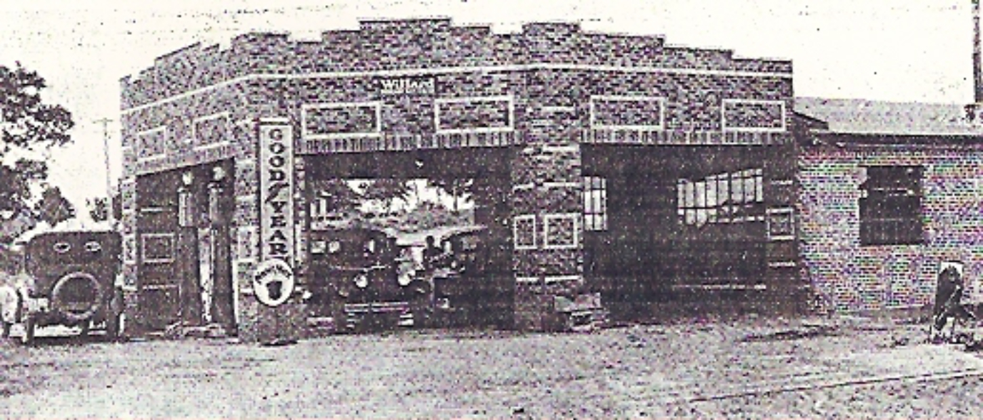
Seaba’s is an irregularly shaped red brick building with five sides. The flat roof is trimmed with the pale cream-colored bricks and the columns and walls are decorated with geometric shapes outlined by the pale colored bricks.
The station and the workshop behind, built by John and Alice Seaba in 1921, opened as a DX station selling that company’s promising brand of gasoline “NevrNox.” The unpaved but well traveled Ozark Trail beside it became U.S. Route 66 in 1926, and was paved with asphalt in 1928 between Chandler and Wellston.
The station building still exists and is structurally much the same, but now it is a Motorcycle Museum, opened in 2010.
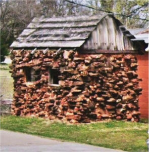
The bathroom at the station was state-of-the-art when it was built in the 1920s and still fine and progressive for 1948. You couldn’t see it from the front, but when you walked around to the left of the station toward Commercial Street, there it was — a freestanding little rock building with his and her sides. It had cast iron flushing toilets that automatically and, to some, irritatingly flushed the entire time a person sat on the rim of the toilet.
This is one of the first plumbed outhouse buildings in Oklahoma, if not the first.
During World War II, the strict Gas Rationing led the Seaba Station to stop selling gas. However, the military used U.S. Route 66 to transport troops, equipment and supplies from one military facility to another, and trucks routinely broke down. Boosted by government contracts to repair the military trucks, John Seaba converted the station to fulltime engine rebuilding and kept the business going.

Luke traveled this road and made this stop before the war. Now, in 1948, he looks around and is surprised and disappointed to find that the gas pumps are gone, and there is a sign reading “Seaba Engine Rebuilding.”
The bathrooms are still there and the three Atkins kids head that direction. The two older are in and out in no time. Four-year-old Nancy, troubled by the constantly flushing toilet, takes a little longer.
When she comes back to the car, Nancy hops in, laughs and says, “Mama that toilet kept splashing water on me; it was getting me.”
Her mama laughs, and, as her daddy pulls back out on U.S. Route 66, her siblings begin to tease her for being bothered by a toilet.
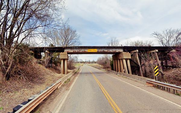
Back on Route 66, the family passes under the 1928 Railroad Trestle that, in 1948, carries the St. Louis and San Francisco Railroad.
1928 Railroad Trestle (theroute-66.com) Now carries the Stillwater Central.

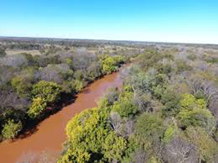
The family passes by the filling station that sits on the south side of Route 66 where the roads meet, drives on a short distance and crosses the murky, muddy, brooding Deep Fork River, which was to the south of U.S. Route 66, and is now on the north.
The Deep Fork River is an Oklahoma tributary of the North Canadian River; it flows through regions of red sandstone hills and red soils and the river is the same color, the color of Oklahoma red dirt.
The Deep Fork River begins in Oklahoma City, flows east, meanders in a northeast, southeast direction, is often fast flowing and sometimes tempestuous; it crosses Route 66 several times and empties into the North Canadian River now impounded by Lake Eufaula in Okmulgee County.
Towns along Route 66 that are also along the waterway are, from west to east, Warwick, Wellston, Luther, Arcadia, where five miles of the river is impounded by the Arcadia Lake, and then Oklahoma City.
The family travels on down the 1948 U.S. Route 66 toward Arcadia.
They will make a stop just before they reach Arcadia at a beautiful place with an expanse of green grass, and a few trees, the same place Washington Irving and his party camped during their tour of the prairies in 1832.
* * * * *
Jo Wilburn
Coming Next – Washington Irving’s Rest Stop.
Notes:
**The Atkins Family: Luke (Father, 38), Grace (Mother, 29), Carl age 10,) Darla (age 6,) Nancy (age 4.)
Because of my need to cut the word count of my book down significantly from nearly 130,000 words, many cuts are those that added to historical value rather than story. It makes me sad because I like those historical references. I hope that by presenting some of those here, I can share an authentic 1948 trip down Route 66 and add a little extra as I go.
I’m considering Chandler the beginning of the 1948 Route 66 journey since that is where the Atkins family picks up Route 66
My parents made a real 1948 trip to California and my mother kept a diary, which I faithfully used in planning this fictional trip.
Credits:
- Jack DeVere Rittenhouse, (1946). A Guide Book to Highway 66
Image Credits:
- R66 Shield Transparent pngegg tiny www.pngegg.com
- 1937 Chevy 4-door Sedan: Photoshop on personal picture.
- 1939 Seaba Station & 1940s Sign: www.seabastation.com
- Rock Outhouse: www.theroute-66.com
- Railroad Trestle: Google Screen Shot Cropped
- Deep Fork River Crossing at Warwick: Google Maps, edited.
- Deep Fork picture through treesLegendary.landm Deep Fork River Ranch, Lincoln County
* * * * *