At the intersection with Sunset Drive, as Luke turns left, he says, “Here’s where we leave Highway 81 that follows the old Chisholm trail. It continues north, but we’re going west again on Route 66 out of El Reno.

In the last blog R66-9 about the *Atkins Family’s 1948 U.S. Route 66 journey west, we left them in El Reno Oklahoma approaching the turn which will lead them away from the city.
In El Reno, the family is traveling north on Choctaw Avenue, also designated as Route 66 and Highway 81. After a couple blocks, they approach Sunset Drive.
At the intersection, as Luke turns left, he says, “Here’s where we leave Highway 81 that follows the old Chisholm trail. It continues north, but we’re going west again on Route 66 out of El Reno.
“Shoot,” Carl says.
Luke smiles. He knows that Carl is fascinated with the old Chisholm trail.
“A little way up that old road, just out of town, it passes over the north Canadian River about where the trail did.”
“Let’s drive that way.”
“No, we need to keep heading west, but we’ll cross over the Canadian River too.”
“Okay.”
Luke continues down Sunset Drive and soon, just after South Grand then South Miles Avenue they pass under the Rock Island Railroad Trestle.
The original US 66 alignment in 1926 was a dirt road with deep ruts. In 1927, Sunset drive, then called Russel Street, was graded, drains were built and a grade crossing at the Rock Island Railroad was built, and, in 1933, the Railroad Trestle.

1926 Dirt Rock Island Crossing (odot.org)
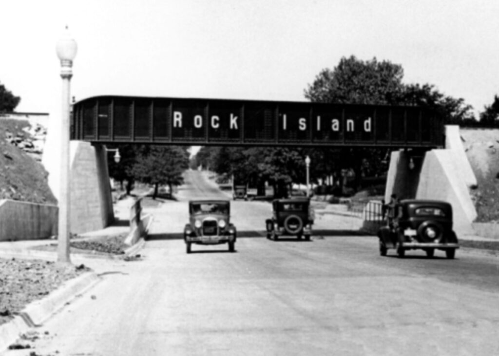
1930s Rock Island Trestle(odot.org)
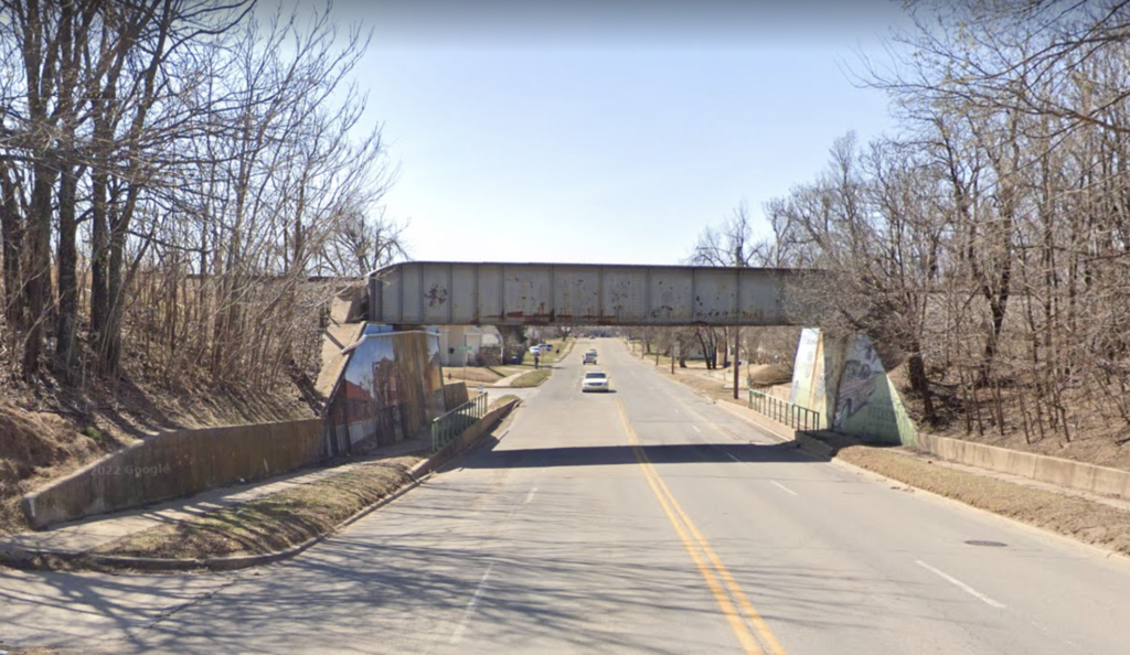
El Reno Railroad Trestle Now(google)
A little further on, they drive by the Phillips Courts on the left between South Mahan Avenue and South Boynton Avenue. It has a U-shaped layout with the office in the middle and with gas pumps in front of the office.
Grace asks, “Do we need gas?”
Luke glances down at the gas gage, “No, we can make it to Hydro, I think. I’ll stop there.”
“We could stop for drinks,” “Darla says, “I’m thirsty.
“We’ve got water or Kool-Aid. You can have either one, but we aren’t stopping until we get gas.”
“Kool-Aid,” Darla says, and Nancy chimes in saying that she wants some too.
Grace reaches into the sack beside her feet and pulls out the big jumbo thermos and a couple cups and pours Kook-Aid about two-thirds up in each and hands them to the girls.
“Be careful and don’t spill,” she says, and they promise they won’t.

Phillips Courts in 1940, El Reno (Archive.org)
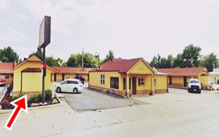
The Phillips Courts are now the Budget Inn. The bay windows are still there, though windowless. The gas pumps are gone, and the motel has added another eastern wing.
After Country Club Road, along with Route 66, Luke curves to the northwest crossing Adams Park and then the road curves back to again head west.
Adams Park was established not long after 1941 after the land (120 acres) was left to the city for that purpose by Lawrence G. Adams, a pioneer El Reno Resident, who died on July 25, 1941. Adams Park is still a well-maintained area.
As the family approaches Sabra Pass, they see a sign announcing a coming-soon drive in movie theatre.
At Sabra Pass they see on their left evidence of construction.
Luke says, “That must be where they’re building the drive-in. Looks like it will be a nice one.”
Carl says, “Wish we could go.”
“Well, not there, not unless we want to wait around three months until September, but we’ll go to another drive-in before too long.”
“I love drive-in movies, they’re fun,” Carl says.
“I like them too.”
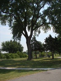
Adams Park (waymarker.com)
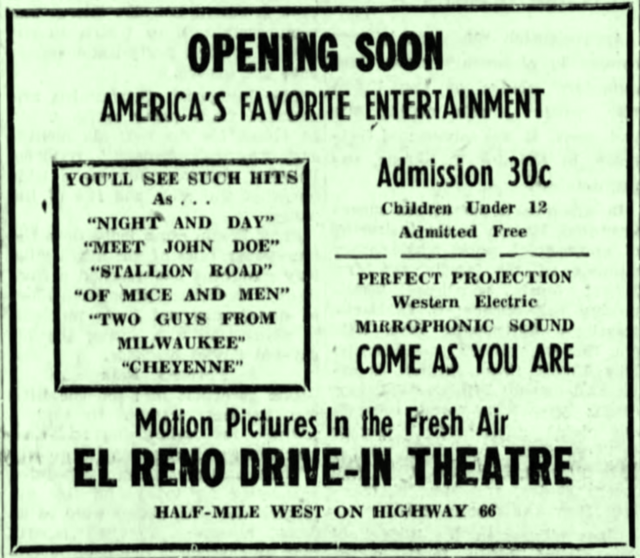
The El Reno Drive-in Movie Theatre located beside U.S. 66 at 600 Sabra Pass, opened on September 11, 1948 with Fredric March in “There Goes My Heart”.
By 1955 it was operated by Video Independent Theaters Inc., and had been renamed the Squaw Drive-In. It was taken over by Martin Theatres in May of 1983 and was closed around 1985.
Sign (cinematreasures.org)
The back side of the movie projection screen has recently received a paint job in the form of an elaborate mural. According to the Oklahoma Route 66 tourist guide it is the “Guardian of the Mother Road Mural.” Designed by Tulsa-based Rick Sinnett, the bird is a scissor-tailed flycatcher, the Oklahoma state bird.
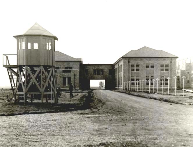
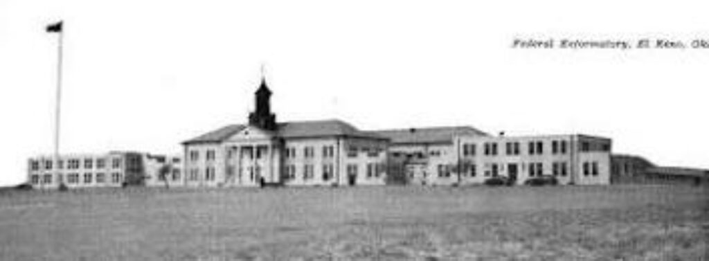
Another couple of miles west of El Reno on the left, Luke sees first the turnoff and then the large buildings of the U.S. Southwestern Reformatory.
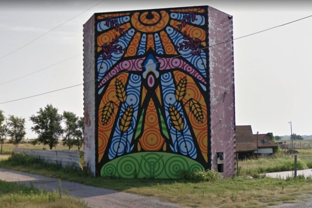
Squaw drive-in mural (Google)
U.S Southwestern Reformatory (okhistory.org)
The U.S. Southwestern Reformatory (Now Federal Correctional Institution) cost over a million dollars to build in 1934. The buildings are erected around a rectangular court in the western section of a thousand-acre tract formerly a part of the Fort Reno Military Reservation. It is clearly visible from Route 66. When built, it was the fifth-largest prison in the US and to this day is a large local employer.
Below: Administration Building (idm2011.weebly.com)
As they drive alongside, Luke points to his left at the facility, “Kids, look, that’s a reformatory, same thing as a prison, but this one is for first offenders, short-term prisoners, those under thirty-five years of age, those who haven’t done anything really violent.”
“Wow!” Carl says, “I’d hate to have to live there.”
“Keep your nose clean and you won’t have to.”
“Carl’s nose isn’t always clean,” Darla says.
“Yeah, sometimes it has boogers,” Nancy says and laughs.
Luke chuckles and says, “That just means behave and obey the laws.”
“Next time he breaks a rule maybe somebody will send him there,” Darla says, a little excited.
“Rules aren’t always laws,” Carl says. “You don’t know what you’re talking about.”
Darla shoots back, “No, you don’t. Some of them are laws and you don’t know which ones, ha, ha.”
Grace says, “Kids, just follow one rule, the golden rule, and you won’t have to worry about it.”
Another couple miles or so further on.
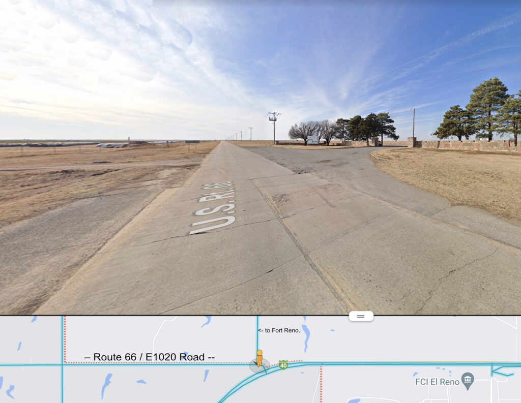
Just as Route 66 joins E1020, the Atkins family sees the turnoff for Fort Reno on the right. The buildings of the fort are not visible from the road, but they see horses grazing along the nearly four-mile stretch of road on the thick green grass range of the fort. The sign beside the turnoff says it’s now an Army Quartermaster Remount Station.
Fort Reno Turnoff (google screenshot cropped)
“That sounds weird,” Carl says. “What’s a remount station?”
“Oh, they raise and train horses and mules for the rest of the army.”
“I’d like to have one of those horses, one like I had, like Old Dick. I wish I still had Old Dick.”
“He was a good horse all right, but he was getting really old when we had to sell him.”
“I could get Old Dick going so fast. He didn’t seem old to me.”
“Well, he was.”
“When will I ever get another horse?”
“I don’t know son; I just don’t know.”
Carl scoots back in the seat and looks out the side window watching the horses. Soon, he asks, “Why does the army need horses or mules anyway? They’ve got jeeps and trucks.”
“You can’t hardly take a jeep up a big rocky mountain or into a dense forest; your Uncle Tommy was in this last war, and he said they went into some places where there wasn’t a square foot of level ground. Believe me, they sometimes need pack animals.”
“Hmmm.”
Up the turnoff road 1.8 miles is Fort Reno. The post was originally established in July of 1874 to protect the old Darlington Indian Agency on the opposite bank of the North Canadian River from Cheyenne Indian forays, and to provide security in Cheyenne & Arapaho lands.
Fort Reno’s first commander General Phillip Sheridan named the fort after his friend General Jesse Lee Reno (1823 – 1862) who had been killed in Maryland September 14, 1862, at the battle of South Mountain during the Civil War. A monument for him stands at Sunset Drive and South Bickford in El Reno, one block east of the Sunset Drive / Route 66 intersection.
By 1880 there were three hundred cavalrymen stationed at the garrison. For the next five years, the troops were kept busy expelling Boomers from the area, and during the run of April 22, 1889, they guarded the boundary of the new land opened to settlement to keep the Sooners from jumping the line ahead of the starting gun. They also supervised the two later land distributions of 1892 and 1894.
After settlement, the need for troops decreased, but the United States Cavalry units from Fort Reno maintained the peace throughout the area and played an important role in the transition of the area from Indian Territory status to Oklahoma statehood in 1907.
The fort was abandoned in February 1908, but re-established two months later in April as one of three Army quartermaster remount stations, and, by 1941, was the United States Army’s largest remount station.
During war, specialized horse breeding and the training of pack mules became the central focus of activity at Fort Reno. The horses and mules were transported by rail from Fort Reno and shipped to other parts of the world during World War I and World War II.
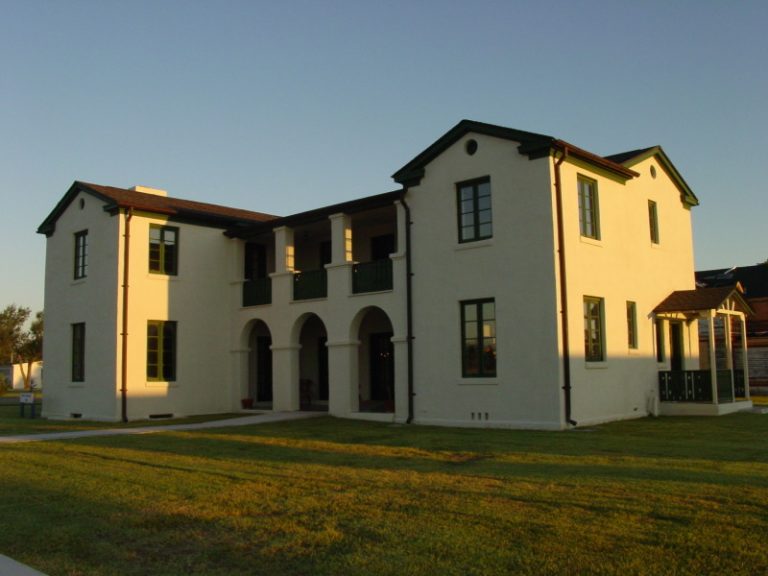
1936 Veterinarian Quarters (fortreno.org)

Chisholm Trail and Fort Reno Marker (hmdb.org)
The above building, which was the veterinarian quarters, is now the visitor’s center. Alongside it is a memorial plaque for the Chisholm Trail.
The Chisholm Trail crossed from Texas into Indian Territory at Red River Station. It ran north roughly along the path of present-day Highway 81 through Oklahoma, branching into an eastern and western trail just before crossing the South Canadian River, and merging back into one trail after crossing the Cimarron River. It then continued northward into Kansas south of Caldwell.
The Land Runs into the Unassigned Lands opened central Oklahoma to settlement, brought fences and towns and effectively ended the trail drive era.
Note: Click the link below to view an excellent 1933 Chisholm Trail Map.
https://www.okhistory.org/publications/enc/viewer?entry=CH045&id=239#page/0/mode/1up
Note: Keep in mind that cities, counties, and highways mentioned existed when the map was created in 1933, but not when the Chisholm trail was in use.
Carl scoots forward in his seat behind Grace and looks across at his father, and asks,
“Daddy, do you know anything else about Fort Reno?”
“Only that a hundred acres of it became a Prisoner of War Camp during World War II. It was a work-camp and there were about 1300 German and Italian prisoners there.”
“Wow! I bet they were mean like in the movies. I wonder if they got tortured?”
“I don’t think so unless you consider work torture. They worked at the camp, and they were hired out as laborers to local farmers.”
“I wouldn’t hire them if I was one of those farmers.”
“You would. Farmers were shorthanded with so many off fighting in the war. Besides, I heard the prisoners behaved themselves pretty well.”
In 1944, the prisoners built the Post Chapel.

Fort Chapel built 1944 by POWs (fortreno.org)
There is also a cemetery on the Fort Reno grounds with burials that date from 1874 to 1947; the west side is where seventy German and Italian Prisoners of War are buried. Most of these men died at other POW camps in Oklahoma and Texas. Only one Fort Reno German POW died while imprisoned at the Fort Reno internment camp.
The fort continued as a remount station through 1948, then was decommissioned, but the animals weren’t shipped out until 1952. Fort Reno has since been the site of the U.S. Department of Agriculture’s Grazing lands Research Laboratory.
After about four miles alongside Fort Reno, the E1020 road ends and 1948 U.S. Route 66 continues west along with the Atkins family.
* * * * *
Coming Next – On west across Pony Bridge to Caddo County
Notes:
*The Atkins Family: Luke (Father, 38,) Grace (Mother, 29,) Carl (Son, 10,) Darla (daughter, 6,) Nancy (daughter, 4.)
My parents made a real 1948 trip to California and my mother kept a diary, which I faithfully used in planning this fictional trip.
I started this blog after completing my novel “Tumbleweed,” which has not yet found a home. Part I of the book includes their 1948 trip, and I did so much research to make it authentic that I didn’t want it to go to waste. However, doing the blog, I’ve had to do even more. It’s been a labor of love. I hope you enjoy this 1948 trip heading west down Route 66.
Credits:
Jack DeVere Rittenhouse, (1946). A Guide Book to Highway 66
www.okhistory.org Encyclopedia of Oklahoma History and Culture
HMdb.org – regarding the Chisholm Trail Marker at Fort Reno
Image Credits:
Standard:
1937 Chevy 4-door Sedan: Photoshop on personal picture.
R66 Shield pngegg.com
For this Blog Episode:
01 1926 Rock Island Crossing Odot.org
02 After 1933, 1930s RR Trestle reddit.com
03 RR Trestle now Google screenshot cropped/notated
04 Phillips Courts in 1940 Archive.org
05 Phillips Courts Recent theroute-66.com
06 Adams Park waymarker.com
07 El Reno Drive-in Ad cinematreasures.org
08 Squaw Drive-in Mural Google Screenshot Cropped
09 U.S. Southwestern Reformatory Okhistory.org
10 Reformatory Administration idm2011.weebly.com
11 Fort Reno Turnoff Google Screenshot Cropped & notated.
12 Veterinarian Quarters fortreno.org
13 Chisholm Trail Marker hmdb.org
14 Fort Reno Chapel fortreno.org
Thanks for the post
_________________
https://bansports.website