Luke drives on, looking around, as is his habit, turning his head this way and that, seeming to barely glance at the road ahead. Grace says, “You’re going to run us off the road or into another car.” Luke laughs.

In the last blog about the *Atkins Family’s 1948 U.S. Route 66 journey west, the family, in Oklahoma County, has just left the small town of Arcadia driving a distance of about ten miles into Edmond Oklahoma on 2nd Street, also designated as U.S. Route 66.
Nancy, the four-year-old is lying down on a pallet between the seats that her daddy made earlier by piling up quilts even with the back seat. She’s listening to the road go by when the thump, thump, thump of the tires crossing road sections suddenly becomes an uneven scramble of noise and car squeaks. She pops up. They’ve just passed N. Douglas Blvd and Luke and Grace remark that the road is significantly different. Here it is still the original brick, as paved in 1926. They slow a bit because of the rougher ride. It continues on for 3.1 miles and ends at Sooner Road in Edmond, Oklahoma.
Then it gets worse. For another 2.8 miles, these bricks, laid in 1924 before Route 66 was designated, are in even worse shape.

After bumping off the bricks and leaving them behind at South Rankin Street, the streets return to normal pavement.
The family continues down 2nd Street. On their left side of the street, they pass the 1889 Territorial Schoolhouse at 124 E 2nd St., the oldest school in Oklahoma. The Atkins family passes by it unaware because, in 1948, it is a private residence, with no indication of the structure’s history or its historical significance.

Above: Original photo c1890; Right: After Restoration

In 1889, within weeks after the April 22nd land run, the Ladies Aid Society, was formed, led by Jennie Forster, and with fifteen women members. They bought the lumber on credit; community volunteers built the one room schoolhouse, and the women raised the money to pay for it. It was completed in August and classes began September 16, 1889 with 19 students.
The school was located on the southwest corner of 2nd and S. Boulevard, and the property stretched west to Broadway and provided plenty of schoolyard for the children, but Edmond outgrew the one room schoolhouse in ten years. The building and land was sold in the last months of 1899, and converted to a private residence, and over time became lost in obscurity, until it was reclaimed toward the end of the twentieth century by the Edmond Historical Preservation Trust and restored in the early 2000s, with its dedication in 2007.
Shortly after Luke passes the school, he says, “Grace, could you get the map and find the belt line. I don’t want to go through downtown this late in the day.”
Grace picks up the map, finds the route and says, “Okay, just keep going west on 2nd Street until you get to N. Kelley Ave. Turn left there.”

Luke turns and drives south on N. Kelley Ave, looking around, as is his habit, turning his head this way and that, seeming to barely glance at the road ahead.
Grace says, “You’re going to run us off the road or into another car.” He just laughs.
As he pulls to a stop at the East Memorial Road intersection, he sees the Memorial Cemetery on his left. Grace looks too and says, “That’s a big cemetery,” and then adds, “I had a great aunt that was buried there when I was young.”
Darla scoots up in the seat and asks, “Did I know her?”
“No, I was only about ten when she died.”
“If we had time we would stop and visit her grave, but we better go on,” Luke says.
“I don’t even know where her Gravesite is. Never really knew her well.”
Luke nods, and then says, Wiley Post is buried there too”
Darla asks, “Who is that?”
“Oh He’s the guy who was flying the plane when Will Rogers got killed. I remember the date they crashed in Alaska, August 15th, 1935. They both died.”
He doesn’t mention that Wiley was also the first pilot to fly solo around the world in 1933. Luke is a Will Rogers fan, not a Wiley Post fan.
“So is Will Rogers buried there too?”
“Nope. He’s buried in Claremore Oklahoma where he lived for a while.”
“Oh.” Darla says and scoots back in the seat again.
“Wiley was only 37 and Will Rogers was just shy of 56,” Luke continues. “I really did like ole Will. He was a down-to-earth guy, smart too. He told it like he saw it. ”
Luke drives on. With Grace directing, they turn west on Britton Road.
A couple miles down, just before they need to turn south again, they approach the Owl Courts Motel.
Grace says, “Do we need to stop for gas. We could stop there at The Owl Courts.
“No, we’re still good on gas. I don’t want to stop here in town.”
“Where are we going to sleep tonight?” Grace asks.
“Not here, not in a big city.”
When they approach the next intersection, Grace again looks at the map and the posted highway signs and says, “Luke, it looks like you have two choices for the beltline – either turn south here on Western, or continue going straight a couple more miles and turn south on May, your choice.”
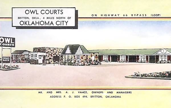
The Owl Courts at 742 W. Britton Rd., were built back in the early 1930s on the brand new 1931 Beltline. It included a gas station and a Café.
The Atkins family will continue through the Oklahoma City area in the next blog, traveling down the Route 66 Beltline that takes them from Edison into Oklahoma City to reconnect with the U.S. Route 66, the City Route, and continue west out of the city.
* * * * *
Coming Next – Oklahoma City Part 3, Leaving Oklahoma City, Bethany
Notes:
*The Atkins Family: Luke (Father, 38), Grace (Mother, 29), Carl age 10,) Darla (age 6,) Nancy (age 4.)
Because of my need to slash the word count of my book from nearly 130,000 to fewer than 100,000, many cuts are those that added to historical value rather than story. It makes me sad because I like those historical references. I hope that by presenting some of those here, I can share an authentic 1948 trip down Route 66 and add a little extra as I go.
My parents made a real 1948 trip to California and my mother kept a diary, which I faithfully used in planning this fictional trip.
Cuts: They have been made to my book and it is now about 98,400 words. Yeah!
* * * * *
Credits:
- Jack D. Rittenhouse, (1946). A Guide Book to Highway 66
- okcrt66.pdf www.okhistory.org
- “The Oklahoman” Robert E. Lee, Jan 2 1998.
Image Credits:
- 1937 Chevy 4-door Sedan: Photoshop on personal picture.
- R66 Shield pngegg.com
- Brick Road Route 66 History sight
- 1889 Territorial School (2) Google Screenshot / www.waymarker.com
- Memorial Cemetery Google Maps Screenshot crop
- Owl Courts www.theroute-66.com