At Western Avenue and Classen Boulevard, Luke follows the Route 66 Beltline, which angles southwest across the railroad tracks toward Belle Isle Lake and then turns south again.

In the last blog about the *Atkins Family’s 1948 U.S. Route 66 journey west, the family has reached Edmond Oklahoma and, in order to bypass the Oklahoma City downtown area, they have taken the Route 66 Beltline.
They are now on Britton Road approaching its intersection with N. Western Avenue. They have a choice to turn south here, or continue on a couple miles to N. May Avenue and turn south. Either choice will take them to 39th Street where they will rejoin the city route of U.S. Route 66.
“I’ll turn here,” Luke says as he makes the left onto N. Western Avenue.

1930s Pat Pugh Ford Building. 9101 N. Western Ave. The building, an example of Mission architecture, has been repainted and the windows altered somewhat, but it is still recognizable as an auto dealership.
Luke is not happy with the way the car is running, and he’s already figured out that he is not getting nearly the gas mileage this car normally gets. About half a mile down Western Avenue they see the Ford Garage.
“I’m tempted to stop at that Ford place right there and let them check the carburetor, but they sell new cars. I see the showcase. I figure they’d be really expensive.”
“Yes, let’s just keep going.”
Just past the Ford Garage on the opposite side of the street is Dinah’s Diner.
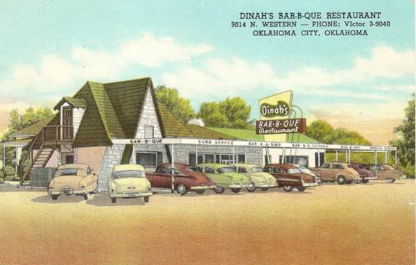
10-year-old Carl points and says, “Can we stop there to eat?”
“No, we’ve still got a little food left from earlier. We’ll eat that,” Luke answers.
“I’d rather stop.”
“I’d rather not.
They drive on by.
At Western Avenue and Classen Boulevard, Luke follows the beltline, which angles southwest across the railroad tracks toward Belle Isle Lake and then turns south again.
He makes a right on 39th Street where the Beltline 66 merges back with the City Route 66 .
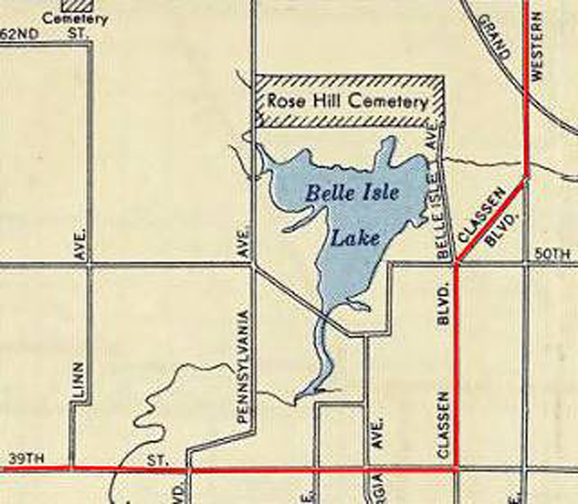
This 1948 Shell roadmap shows N Western Ave on the right side, and, from the north, after crossing the Deep Fork River, Classen Boulevard branches with a SW course, turning south again at NW 50th Street. Belle Isle Lake lies just west of it.
Bell Isle Lake was built by the Oklahoma Railway Company just after statehood in 1907 to power the city’s streetcar system. Beginning in 1954, it was filled in and the street configuration changed, in order to complete construction of I-44.
The river or creek shown snaking into the south end of the Lake and exiting from the upper-east side is Deep Fork Creek. It was dammed and used to feed Belle Isle Lake.
The Atkins family continues south on Classen Blvd until they make a right on 39th Street where the Beltline 66b merges back with U.S. Route 66
A summary of the complete Route 66 Beltline route that Luke and Grace have taken is as follows.
After coming into Edmond on 2nd Street / Route 66, they make a left to travel south on S. Kelley Avenue for about six miles, then turn right and travel west on E. Britton Road for a couple more to N. Western Ave. They turn left and travel south again for almost three miles. Just before N.W. 50th Street, at Classen Boulevard, they angle southwest, and with it turn straight south again for another mile or so to 39th Street to rejoin U.S. Route 66 traveling west.
Even with taking the faster beltline route, traffic was heavy; it is close to 6 p.m. when the family reaches the western edge of Oklahoma city and pass by, on the north side of 39th Street, the mostly residential town of Warr Acres.
War Acres was a new town in 1948, established by a dynamic businessman named C.B. Warr after the Second World War. It had been officially incorporated in February of 1948, and The Atkins passed through in June of that year.
According to an article in the Oklahoman, the exact location of the headwaters of the Deep Fork River, which is prominent in Oklahoma and unique to the state, originates from a spring in a grove of scrubby blackjack trees located a half-block to a block south of N.W. 39th Expressway and Ann Arbor, which would put it in Warr Acres. From there the Deep Fork flows along the now dry Belle Isle Lake, travels alongside I-44 for a ways, then to Lake Arcadia, and into the North Canadian River and Lake Eufaula near Eufaula Oklahoma.
The family continues, still heading west into Bethany and the lowering sun.
* * * * *
Coming Next – Oklahoma City Area Part 4, Bethany
*Notes:
*The Atkins Family: Luke (Father, 38), Grace (Mother, 29), Carl age 10,) Darla (age 6,) Nancy (age 4.)
Because of my need to slash the word count of my book from nearly 130,000 to fewer than 100,000, many cuts are those that added to historical value rather than story. It makes me sad because I like those historical references. I hope that by presenting some of those here, I can share an authentic 1948 trip down Route 66 and add a little extra as I go.
My parents made a real 1948 trip to California and my mother kept a diary, which I faithfully used in planning this fictional trip.
Cuts: My cuts to my book Tumbleweed have been made and it is now about 98,400 words. Yeah!
Credits: Jack D. Rittenhouse, (1946). A Guide Book to Highway 66
okcrt66.pdf www.okhistory.org
“The Oklahoman” Robert E. Lee, Jan 2 1998.
Image Credits:
1 1937 Chevy 4-door Sedan Photoshop on personal picture.
2 R66 Shield www.pngegg.com
3 Ford Garage Old Google Screenshot – edited
4 Dinah’s Diner www.66postcards.com
5 1948 Shell Rte 66 Beltline Map www.theroute-66.com
6 Warwick City Seal www.warracres-ok.gov
* * * * *