In Yukon on Route 66, as Luke drives across 9th street, he says, “The Chisholm Trail went through Yukon, and passed right here at this spot.”

In the last blog R66-7 about the *Atkins Family’s 1948 U.S. Route 66 journey west, the family has driven through Oklahoma City, taking the Beltline Route 66 in order to bypass the downtown area, and have traveled through Bethany and left the city crossing the Overholser Bridge.

Lake Overholser Bridge (theroute-66.com)
As they exit the bridge in 1948, Route 66 goes straight for a short distance then begins to curve south. At the beginning of this downward curve they leave Oklahoma County and enter Canadian County. Soon the road curves back west to follow the north shoreline of Lake Overholser on their left. Luke slows to better enjoy the views. The drive is beautiful.

Lake Overholser (www.TravelOK.com)
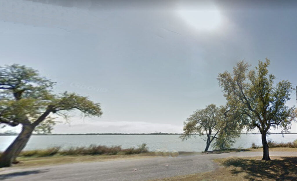
Lake Overholser (Old Google Screenshot, Cropped.)
Several families have stopped along the water’s edge and are relaxing in the shade. Luke pulls over as well and stops facing the lake, but they don’t get out of the car. They sit for a while just watching the water.
Carl, leans forward, “Daddy, I saw a sign that says you can rent a boat and take a ride. Let’s do it, Can we?”
“No, we don’t have the money to waste. Besides, “It’ll be dark soon. We don’t have time; We need to get going in a minute.”
Soon Luke pulls away from Lake Overholser, curves around the western edge with the road and back west again to travel the short distance to Yukon, where Route 66 enters on Yukon’s main street originally called Spencer Avenue.
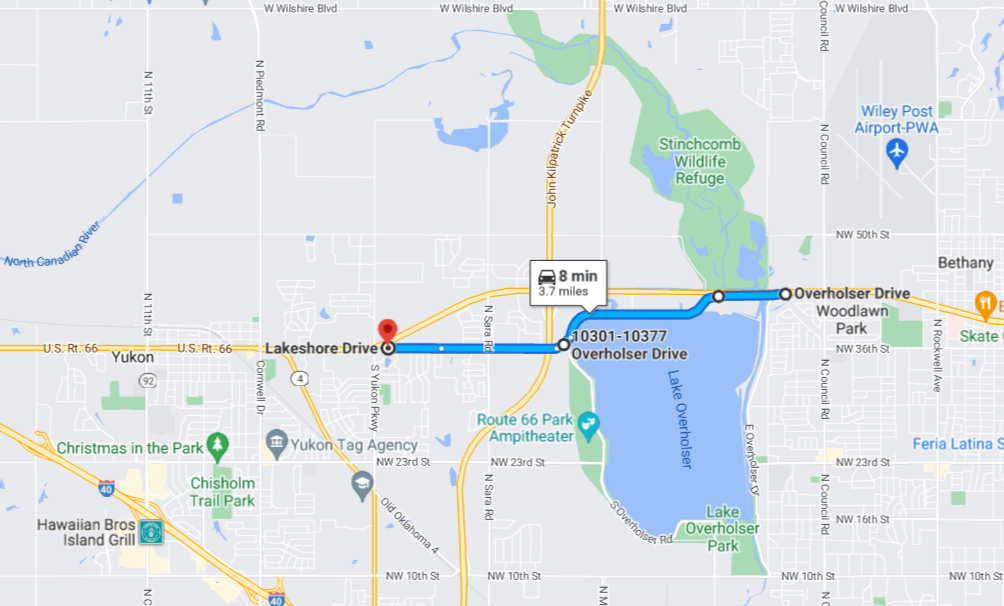
Route 66 into Yukon: Current Google Map Screenshot, Cropped.
Lake Overholser furnishes the water supply of Oklahoma City. It was built around 1916 by constructing a dam on the N. Canadian River.
Today, although Yukon is in Canadian rather than Oklahoma county it is still considered part of the Metropolitan Oklahoma City area.
Yukon was founded in 1891 by A. N. Spencer in Canadian County, the name is from a Native American word “yu-kan-ah” meaning “Big River.”
The county was originally County Four, renamed after the 1889 Oklahoma land run as Canadian County after the Canadian River which runs through it.
Yukon began as a farming community and the main industry was the Yukon Mill and Grain Company, founded in 1893 at 220 W. Main Street, and later purchased by Czechoslovakian immigrant brothers, John F. Kroutil and Frank L. Kroutil, and their brother-in-law, Anton F. Dobry, in 1903. It became one of the largest milling industries in the state and was the largest employer in Yukon and adopted the slogan “Yukon’s Best Flour”
Yukon Mill and Grain Company encompassed the southwest corner of West Main Street and the railroad tracks belonging to the Choctaw, Oklahoma, Gulf Railroad Company, later know as the Chicago, Rock Island, and Pacific Railroad.
In 1933, Dobry sold his interest to his partners and by 1935 had constructed Dobry Flour Mills, Inc. across the street at 219 West Main Street. It was later sold to the Oklahoma Farmers Union Cooperative in early 1953 after Dobry’s death.
In 1948, Luke drives down Yukon’s Main Street. Just before N. 3rd street on the right at 219 W. Main he passes the large and imposing Dobry Flour Mills

1940s Dobry Flour Mills (Credit: AHSofdowntownYukon.pdf)
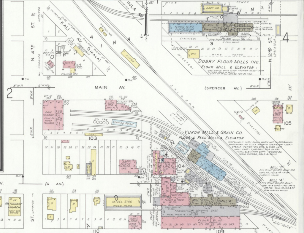
1943 Sanborn Map (Credit: theroute-66.com)
The above map, published by Sanborn Map Co. in 1943, shows the area where Route 66 (marked Main Av. and Spencer Av.) crosses the tracks, and clearly shows the Dobry Flour Mill east of the tracks on the North side of Route 66, which runs left to right, i.e., west to east. The tracks run diagonally across the image in front and west of Dobry Flour Mills and beside and east of Yukon Mill and Grain Company.
You can see the now gone depot of the Rock Island Railroad (yellow building) on the north side of Route 66, beside the C R I & P R R (Chicago, Rock Island, and Pacific Railroad) rails. To the left, also in yellow, is the “Interurban Depot”.
The “interurban” was an electric streetcar. They were built in wood and looked like regular railroad passenger cars but were powered by overhead electric lines.
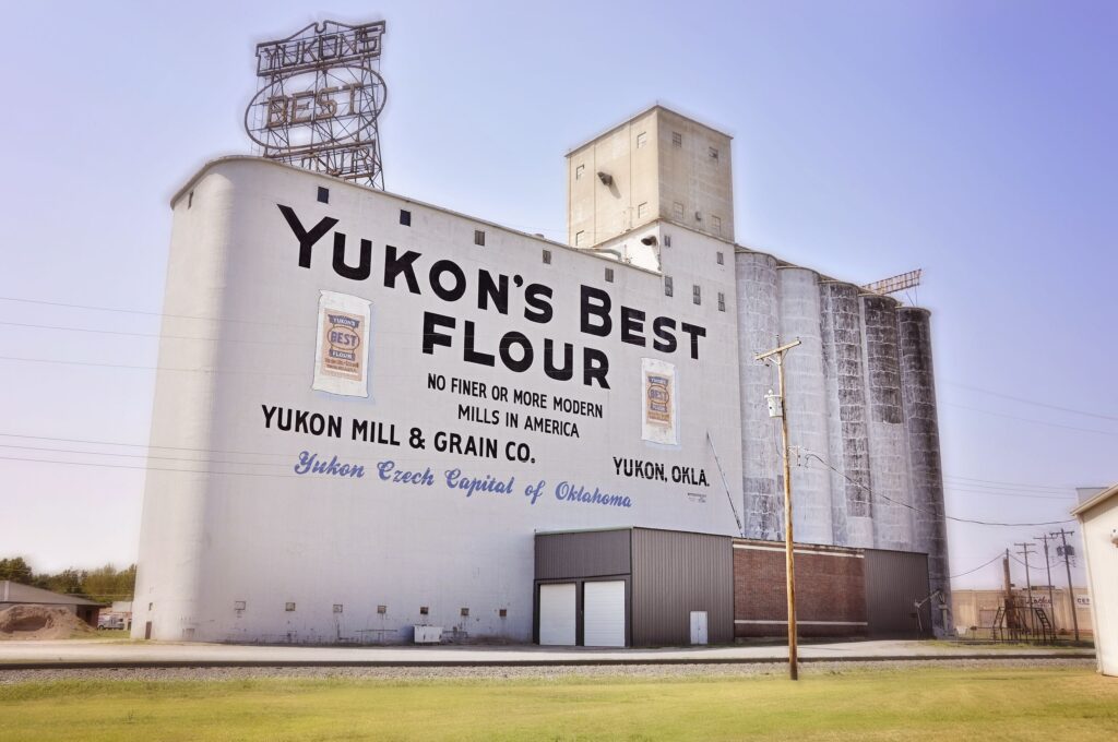
Yukon Mill and Grain Co. (Credit: Kristi Ellis, Wikipedia)
Luke drives across the railroad tracks and on the left side of the road the Atkins family passes the equally impressive Yukon Mill and Grain Company.
Later, in 1972, Shawnee Mills purchased both the Yukon Mill and Grain Company and what had been Dobry Mills — the Cooperative (now called Mid-Continent Farmers Cooperative, or MFG Farmer’s Co-Op.)
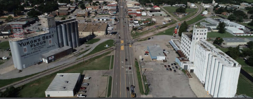
Current Yukon shot (www.yukonok.gov) Looking from east to west
Yukon Mill & Grain Co. and MFG Farmers Co-Op (formerly Dobry Flour Mills)
Just past the tracks, on the right, at 315 W. Main, set back off the road is the still existing Interurban Depot previously mentioned. The Interurban Line began around 1911 and linked Yukon with El Reno, and Oklahoma City.
After World War II, with the end of rationing and growing auto mobility, the trolleys disappeared. This one ceased operation in 1947.

Yukon Interurban Depot (TheRoute-66.com)

Yukon Courts (www.theroute-66.com)
On the southeast corner of 9th and Main is the Yukon Courts. It has an L-shape layout around the office that is located on the corner.
A big neon sign draws Carl’s attention to it. It has iron columns on the porch, and gable roofed units.
Note: The Neon Sign is now gone.
Carl looks longingly at the tourist court, “Dad, Dad, let’s stop there.”
“No, “We’re not stopping there. It’s too early anyway.” Luke answers without even looking. His focus is on the Standard Sign and Filling Station across the street on the Northeast corner of 9th and Main.
This station originates from 1942 and the round Standard sign is classic, also from that period. Now, beside the Standard sign is a smaller rectangular one that marks this spot as a Chisholm Trail Crossing.
Luke suspects this station may be the last one in town. He slows, glances down at the gas gage and decides he’s okay for a while.
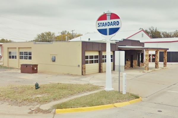
Standard Station (theroute-66.com)
For a couple seconds, Luke looks around the area. As he drives on across 9th street, he says, “The Chisholm Trail went through Yukon, and passed about right here at this spot.”
“What’s that?” Carl asks.
“A trail that went from Texas all the way across Oklahoma into Kansas. After the Civil War cowboys drove cattle along it from Texas to the railhead in Kansas.
“Why did they do that?”
“To sell. There was a big difference in price in Texas and in the north and east. Where they were shipped from Kansas. It was all about money. I heard that right after the Civil War the price difference was ten times more in the north and east — $4.00 in Texas and $40.00 there.”
“Why?”
“Well, it’s the supply and demand thing. There were so many in Texas because they multiplied on their own during the war, and not many in the north or east and there was a big demand for beef.”
“Wow, I wish I was a cowboy.”
“Well, they didn’t usually get the $40.00 per head. Most of the cattle were shipped east on the railroad to beef packers. They got whatever they could get in Kansas at the Railhead Stock Yards. The Kansas people, the middlemen, got the $40.00.”
“Shoot.”
“Being a Cowboy was hard work too. I haven’t done that, but I’ve done enough ranch work to know it would have been long tiresome days trying to corral and drive two or three thousand head of cattle during the day, and sleeping rough at night.
“Anyway, they stopped close to where we are now at some fresh water pond to make a campsite and rest, and they watered their cattle at the Canadian River just north of Yukon.”
“Could you go down that trail now if you wanted to?”
“I don’t know, but I’ve been told that Highway 81 pretty much follows that old trail.”
“I’m gonna go down it when I get grown.”
“That would be fine. I hope you do.”
* * * * *
Coming Next – El Reno and on West
Chisholm Trail Notes
According to TravelOK.com, the Chisholm Trail crossed through the intersection of present-day West Main Street and 9th Street and was used as a cattle herding trail between Texas and Kansas across Indian Territory (Oklahoma) during the late 19th century.
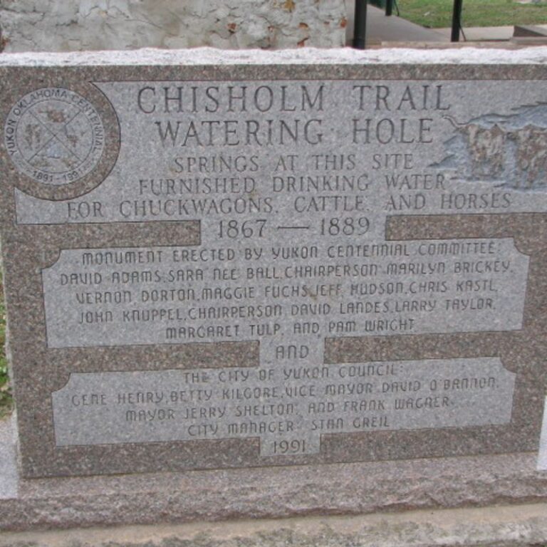
Chisholm Trail Watering Hole Marker (www.travelok.com)
Other sources have the trail going through or near the Yukon City Park. A Chisholm Trail Watering hole marker is located at 2100 S Holly. The 9th and Main intersection crossing is a bit north and just slightly west of the marker
Overall, the best information I’ve found regarding the Chisholm trail across Oklahoma includes a map and associated information written by Steven D. Dortch.
Find it here: https://www.okhistory.org/publications/enc/entry.php?entry=CH045
Notes:
*The Atkins Family: Luke (Father, 38), Grace (Mother, 29), Carl age 10,) Darla (age 6,) Nancy (age 4.)
Because of my need to slash the word count of my book considerably, many cuts are those that added to historical value rather than story. It makes me sad because I like those historical references. I hope that by presenting those and my additional research here, I can share an authentic 1948 trip down Route 66 and add a little extra as I go.
My parents made a real 1948 trip to California and my mother kept a diary, which I faithfully used in planning this fictional trip.
Credits:
Jack DeVere Rittenhouse, (1946). A Guide Book to Highway 66
TravelOK.com and Okhistory.org
AHSofDowntownYukon.pdf (Architectural Historic Survey of Downtown Yukon)
Image Credits:
1 1937 Chevy 4-door Sedan: Photoshop on personal picture.
2 R66 Shield pngegg.com
3 Overholser Bridge www.theroute-66.com
4 Overholser Lake 1 1) www.travelok.com 2) Google Maps Screenshot
5 Route 66 into Yukon Google Maps Screenshot crop
6 1940s Dobry Flour Mills www.okhistory.org (AHS…pdf)
7 1943 Sanborn Map www.theroute-66.com
8 Yukon’s Best Flour Mill Kristi Ellis, Wikipedia.org
9 Yukon Mills Aerial shot yukonok.gov Yukon_Comp_Plan_7_14_2020_small
10 Yukon Interurban Depot www.theroute-66.com
11Standard Station www.theroute-66.com
12 Yukon Courts www.theroute-66.com
13 Chisholm Trail Marker www.travelok.com
* * * * *
A very interesting read and a nice tribute to the family’s courage and determination!
Thanks!